|

Associated
Oil Bridge Construction Folio – 1935
Bonds
to Finance Proposed Golden Gate Bridge – 1930
Photo:
USS California Passes Under the Golden Gate Bridge
Photo:
Pan-American Clipper Passes Over the Golden Gate Bridge
Photo:
Construction of the Golden Gate Bridge South Tower
Photo:
Joseph Strauss and the Golden Gate Bridge Designers – 1930
Bay
Bridge Smashups Spur Planning Conference -1940
16 Views of GG Bridge Construction - PowerPoint 764K
Story
Behind Building the Golden Gate Bridge
Toll
Rates and General Bridge Rules — 1937
Purchase
a Golden Gate Bridge Print
Purchase an
Authentic Golden Gate Bridge Rivet
|
Symphonies
in Steel:
Bay Bridge and the Golden Gate
By John Bernard
McGloin, S.J.
Professor of History
University of San Francisco
San Francisco
can rightly claim to be one of the skyline cities of the nation. Situated
at the tip of a peninsula and built in considerable part upon hills, the
city is surrounded on three sides by the waters of the Golden Gate, the
bay, and the Pacific Ocean. From the air, one notices a thread leading
eastward across the Bay, and another leading northward across the Golden
Gate. These two threads are, of course, two of the truly great bridges
of the world: the San Francisco-Oakland Bay Bridge, opened in late
1936, and the Golden Gate Bridge, opened the following summer.
A plaque
is located at the southeastern corner of Montgomery and Jackson streets
in San Francisco; the text of the inscription reads as follows:
On this
site the first San Francisco Bridge was constructed in 1844 by order of
William Sturgis Hinkley, Alcalde of Yerba Buena. It crossed a creek which
connected Laguna Salada with the Bay and was regarded as a remarkable structure
and great public improvement as it shortened the distance to the town’s
Embarcadero at Clarke’s Point.
San Francisco
and adjacent areas have come a long way in the matter of bridges since
the Hinkley span. Within the 450 square miles of landlocked harbor, San
Francisco Bay has eight major highway bridges, including four of the world’s
greatest steel bridges, as well as two railroad bridges. Four of these
bridges, San Francisco-Oakland, Golden Gate, Richmond-San Rafael,
and Carquinez Straits, are rated among the ten most notable structures
of their kind in the world. Other bridges include the San Mateo-Hayward,
Dumbarton, Southern Pacific’s Suisun Bay and Redwood City-Newark railroad
crossings, as well as the Antioch , Bridge. Easily the most important of
all these are the two bridges that were completed in 1936 and 1937.
Mention
was previously made of Emperor Norton; during his quixotic reign as “Norton
I, Emperor of North America and Protector of Mexico,” he issued
a “decree” that San Francisco Bay be bridged immediately. This was
to remain unfinished business until long after the emperor, as well as
his two dogs, Bummer and Lazarus, had retired from the civic scene. However,
when at length the emperor’s mandate was fulfilled, presumably even his
imperious self would have been satisfied.
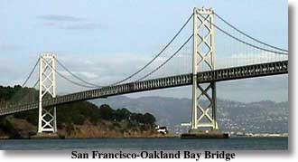 The Bay Bridge
is the longest steel high-level bridge in the world. As mentioned
earlier, the Yerba Buena Tunnel with its diameter of 58 feet, which forms
part of the highway between San Francisco and Oakland, is the tallest bore
in the world. Additionally, the Bay Bridge can boast of the fact that its
construction required the greatest expenditure of funds ever used for a
single structure in the history of man. Its foundations extend to the greatest
depth below water of any bridge built by man; one pier was sunk at 242
feet below water, and another at 200 feet. The deeper pier is bigger than
the largest of the Pyramids and required more concrete than the Empire
State Building in New York.
The Bay Bridge
is the longest steel high-level bridge in the world. As mentioned
earlier, the Yerba Buena Tunnel with its diameter of 58 feet, which forms
part of the highway between San Francisco and Oakland, is the tallest bore
in the world. Additionally, the Bay Bridge can boast of the fact that its
construction required the greatest expenditure of funds ever used for a
single structure in the history of man. Its foundations extend to the greatest
depth below water of any bridge built by man; one pier was sunk at 242
feet below water, and another at 200 feet. The deeper pier is bigger than
the largest of the Pyramids and required more concrete than the Empire
State Building in New York.
On Thursday,
November 12, 1936, at 12:30 p.m. the Bay Bridge was opened to vehicular
traffic; its construction had continued for exactly three years, four months,
and three days. It was the result of years of discussion and planning on
the part of those concerned with providing means of transportation other
than by ferry between San Francisco and the East Bay. The Hoover-Young
Bay  Bridge
Commission (named after President Hoover and California’s Governor C.C.
Young) began sessions in Sacramento in October 1929. With the cooperation
of various state agencies, an engineering and traffic study was made. Finally,
the present route was agreed upon and the considerable financing of the
project was explored. As finally constructed, the Bay Bridge is 43,500
feet or 8 1/4 miles long, from end to end of the approaches. The bridge
proper, including the Yerba Buena crossing, is 23,000 feet or 4 1/2 miles
long. On the San Francisco side of Yerba Buena Island, the structure consists
of two complete suspension bridges with a central anchorage in the middle.
The towers of the suspension rise 474 and 519 feet above water. Over the
east channel, the span continues with one main cantilever span of 1,400
feet and, east of this, five truss spans each measuring 509 feet. The two
cables supporting the suspensions are each 28 3/4 inches in diameter, and
each contains 17,664 wires; the total length of these wires is 70,815 miles,
which is enough to encircle the earth three times. The concrete and steel
used in building the Bay Bridge would build thirty-five San Francisco
Russ Buildings plus another thirty-five Los Angeles City Halls or
L.C. Smith buildings in Seattle. Each of the two principal towers represents
a construction job equivalent to building a sixty-story skyscraper. Bridge
Commission (named after President Hoover and California’s Governor C.C.
Young) began sessions in Sacramento in October 1929. With the cooperation
of various state agencies, an engineering and traffic study was made. Finally,
the present route was agreed upon and the considerable financing of the
project was explored. As finally constructed, the Bay Bridge is 43,500
feet or 8 1/4 miles long, from end to end of the approaches. The bridge
proper, including the Yerba Buena crossing, is 23,000 feet or 4 1/2 miles
long. On the San Francisco side of Yerba Buena Island, the structure consists
of two complete suspension bridges with a central anchorage in the middle.
The towers of the suspension rise 474 and 519 feet above water. Over the
east channel, the span continues with one main cantilever span of 1,400
feet and, east of this, five truss spans each measuring 509 feet. The two
cables supporting the suspensions are each 28 3/4 inches in diameter, and
each contains 17,664 wires; the total length of these wires is 70,815 miles,
which is enough to encircle the earth three times. The concrete and steel
used in building the Bay Bridge would build thirty-five San Francisco
Russ Buildings plus another thirty-five Los Angeles City Halls or
L.C. Smith buildings in Seattle. Each of the two principal towers represents
a construction job equivalent to building a sixty-story skyscraper.
The chief
engineer for the entire project was Charles H. Purcell (1885-1951) whose
competency was matched only by his modesty. Assisting him was Charles E.
Andrew as bridge project engineer and Glen Woodruff as designer. Total
cost of the bridge, including interurban electric rail facilities (since
unfortunately abandoned), amounted to $79.5 million. This was financed
by sale of 4 and 3 percent revenue bonds, which were purchased by the Federal
Reconstruction Finance Corporation. In addition to these bonds, the California
State Gas Tax Fund loaned $6 million for the building of the approaches;
both sums were eventually repaid from toll revenues. (In 1958, a
four-year
reconstruction program was undertaken at a cost of $35 million.) Decreasing
patronage of the interurban trains had caused the Key System Lines to abandon
this service, leaving buses to handle the load exclusively. This reconstruction
involved track removals, conversion of each deck (lower and upper) to one-way
motor vehicle traffic, and the lowering of the lower deck of the bridge
by 16 inches through the Yerba Buena Tunnel. The maintenance of such a
colossal structure keeps a legion of persons constantly at work. No matter
from what angle the San Francisco-Oakland Bay Bridge is viewed, it
will always remain a symphony in steel.
For years,
the Golden Gate Bridge held the title of longest suspension bridge in the
world. Despite the claims that the Mackinac span, which connects the greater
part of Michigan with its upper peninsula across the Straits of Mackinac
is longer, the question is best resolved by settling what is meant, indeed,
by “longer”: actually, the Mackinac suspension is supported by a single
span of cables 8,344 feet in length as compared with 4,200 for the Golden
Gate Bridge. However, the center span of the Mackinac Bridge is exceeded
in length by both the Verrazano Narrows Bridge in New York City and the
Golden Gate Bridge. The claim of “longest” for the Mackinac is based upon
the distance between cable anchorages, while the Golden Gate figure is
based upon the actual distance between its towers. Rival claims, though,
do not seem to be of great importance, since all will admit that, just
as is true of its sister span across San Francisco Bay, the Golden Gate
is “quite a bridge,” the fulfillment of a dream and a vision had by one
man: it is the “bridge that couldn’t be built.”
 Triumphantly,
then, on Thursday, May 27, 1937, San Franciscans joined other thousands
in walking across the newly opened Golden Gate Bridge, all together a huge
throng of approximately 200,000. This “preview” was followed the next day
by dedicatory ceremonies which culminated in the cutting of a ceremonial
barrier, after which an official cavalcade of automobiles traversed the
span; the rest of that day was devoted, again, to pedestrian traffic, and
the regular flow of vehicular traffic started the next day. It has been
written that
Triumphantly,
then, on Thursday, May 27, 1937, San Franciscans joined other thousands
in walking across the newly opened Golden Gate Bridge, all together a huge
throng of approximately 200,000. This “preview” was followed the next day
by dedicatory ceremonies which culminated in the cutting of a ceremonial
barrier, after which an official cavalcade of automobiles traversed the
span; the rest of that day was devoted, again, to pedestrian traffic, and
the regular flow of vehicular traffic started the next day. It has been
written that
Residents
of the San Francisco Bay area feel this bridge as an entity and have a
section for it. They admire its living grace, and its magnificent setting.
They respond to its many moods—its warm and vibrant glow in the early
sun, its seeming play with, or disdain of, incoming fog, its retiring shadowy
form before the sunset, its lovely appearance in its lights at night. To
its familiars it appears as the “Keeper of the Golden Gate.”[l]
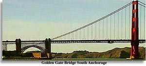
The Golden
Gate Bridge is the result of the long-term determination of the
people of six California counties who, eventually, formed themselves
into a Golden Gate Bridge District comprising the city and county of San
Francisco, Marin, Sonoma, and Del Norte counties, as well as a portion
of Napa and Mendocino counties. Since it had long been apparent that the
bridging of the Golden Gate, despite the many problems its construction
would entail, would mean an effective opening up of the counties north
of San Francisco, much planning went into the implementation of the visions
and dreams of the members of the Bridge District. In 1928, earlier efforts
culminated in the incorporation of the Golden Gate Bridge and Highway District;
in November 1930, the voters of the concerned counties passed a $35 million
bond issue to finance the building of the bridge, while pledging the property
of these counties as security for the payment of the bonds. For many years,
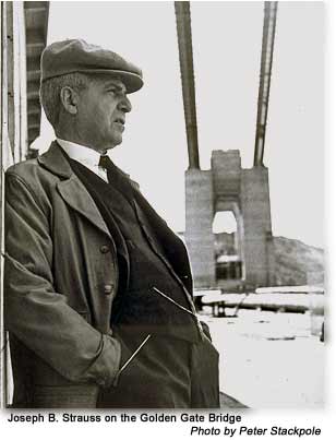
Joseph Baerman Strauss (1870-1938), a distinguished engineer with many
bridges to his credit, had dreamed of raising a span across the Golden
Gate. One who contemplates his many activities realizes that Strauss was
much more than merely a competent structural engineer, although he certainly
was that: he was also a poet, a seer, and a man of vision and it seems
that all these qualities sustained him in the fulfillment of his dream;
it is equally certain that he had to live with the skepticism of his peers
who kept repeating that “Strauss will never build his bridge, no one can
bridge the Golden Gate because of insurmountable difficulties which are
apparent to all who give thought to the idea.” But Strauss held fast to
his vision, and, even though he survived only a year after the opening
of his bridge, he did live to bring it to completion.[2]
 Construction
of the bridge took four and one-half years and the work began on January
5, 1933. The resulting span has been much admired for its magnitude and
its graceful beauty. At mid-span the bridge is 220 feet above the
waters of the Golden Gate; it is about a mile across and there is only
one pier in the water which, incidentally, was built under most discouraging
circumstances, as Engineer Strauss could testify. This pier is only 1,125
feet from shore; the distance between the two towers that support the cables
which, in turn, support the floor of the bridge, is 4,200 feet. These two
cables are 361/2 inches in diameter, the largest bridge cables ever made.
Each cable is 7,659 feet long and contains 27,572 parallel wires, enough
to encircle the world more than three times at the equator. Fortunately,
solid rock was found at each end of the Gate and huge pockets were excavated
in this rock to form a setting for the concrete anchorage blocks, each
of which contains 30,000 cubic yards of concrete. Among the engineering
problems that had to be faced in the building of the bridge were those
that arose from the exposed nature of any such structure, for it has to
withstand winds and gales coming from the often far from peaceful Pacific
Ocean. It was so designed that, in the most unlikely event of a broadside
wind coming at it with a speed of one hundred miles an hour, the bridge
floor at mid span might swing as much as 27 feet.[3] Construction
of the bridge took four and one-half years and the work began on January
5, 1933. The resulting span has been much admired for its magnitude and
its graceful beauty. At mid-span the bridge is 220 feet above the
waters of the Golden Gate; it is about a mile across and there is only
one pier in the water which, incidentally, was built under most discouraging
circumstances, as Engineer Strauss could testify. This pier is only 1,125
feet from shore; the distance between the two towers that support the cables
which, in turn, support the floor of the bridge, is 4,200 feet. These two
cables are 361/2 inches in diameter, the largest bridge cables ever made.
Each cable is 7,659 feet long and contains 27,572 parallel wires, enough
to encircle the world more than three times at the equator. Fortunately,
solid rock was found at each end of the Gate and huge pockets were excavated
in this rock to form a setting for the concrete anchorage blocks, each
of which contains 30,000 cubic yards of concrete. Among the engineering
problems that had to be faced in the building of the bridge were those
that arose from the exposed nature of any such structure, for it has to
withstand winds and gales coming from the often far from peaceful Pacific
Ocean. It was so designed that, in the most unlikely event of a broadside
wind coming at it with a speed of one hundred miles an hour, the bridge
floor at mid span might swing as much as 27 feet.[3]
Practically
all of the Golden Gate Bridge is located within the city and county of
San Francisco (as is the Golden Gate itself). The two towers rise an impressive
746 feet which means that they are 191 feet taller than the Washington
Monument. In 1884, a poet thus saluted the Golden Gate:
Wide Thy
Golden Gate stands open to all
Nations of the world,
Free beneath its stately portals
All flags are in peace unfurled.
Beauteous Gate, when loitering Sunset
Covers Thee with burnished gold.
Mighty Gate, when surging ocean Thy
Strong cliffs alone withhold.
Treacherous
Gate, deceiving many with a
Name most fair-Blessed Gate, where millions
Find the golden boon of liberty. [4]
|
At the completion
of his mighty bridge, Joseph Strauss penned an impressive ode which he
entitled “The Mighty Task Is Done”; it epitomizes his personal travail
in building the bridge and makes of the structure almost a living thing.
From his poem, these lines give evidence of the dedication of the man who
brought the bridge from his brain and heart as well as from his drawing
board:
At last
the might task is done;
Resplendent in the western sun;
The Bridge looms mountain high
On its broad
decks in rightful pride,
The world in swift parade shall ride
Throughout all time to be.
Launched
midst a thousand hopes and fears,
Damned by a thousand hostile sneers.
Yet ne’er its course was stayed.
But ask of those who met the foe,
Who stood alone when faith was low,
Ask them the price they paid.
High overhead its lights shall gleam,
Far, far below life’s restless stream,
Unceasingly shall flow....
|
With the
completion of the two giant bridges, it was but natural that a proud San
Francisco would again wish to call the people of the world to itself; so
it was that another world fair, this one called the Golden Gate International
Exposition, was planned and brought into being. Several years previously,
a movement to develop an airport site by constructing a fill over the shoal
area adjacent to Goat Island (Yerba Buena) was started. Although the airport
was finally placed elsewhere, the planning resulted in a man made island
(called “Treasure
Island”) on which was staged the exposition.
When the
voters of San Francisco decided to have such an exposition, the question
of financing the necessary engineering work was happily resolved. In late
1935, the city of San Francisco succeeded in having the project approved
as a Works Progress Administration (WPA) project. This authorization, including
20 percent to be furnished by San Francisco, amounted to $3,803,900. After
further study, the WPA concluded that the nature of the work required was
such that it could not handle the project. The Secretary of War approved
the request that its execution be undertaken by the Army Corps of Engineers.
While a group of such specialists applied their talents to the reclamation
of the “Yerba Buena Shoals,” the day-by-day details were efficiently
cared for by Colonel Fred Butler, U.S.A., who had years of army engineering
experience behind him at this time. The fill to form Treasure Island was
obtained by dredging operations; the island covered an area of 400 acres,
5,520 feet long by 3,410 feet wide.
Meanwhile,
the San Francisco Bay Exposition Company was formed with Leland W. Cutler
as president. He was greatly aided from the beginning by George Creel,
who was appointed United States Commissioner of the Exposition. By 1938,
1,200 men were employed in horticultural work on the newly born Treasure
Island; they planted 400,000 bulbs, 800,000 seeds, and 4,000 trees. It
then remained for the architects and artisans to accomplish their respective
tasks. The international dimension came only gradually as Leland Cutler
persuaded those concerned that an invitation should be extended to other
countries to join in the celebrations. A subtitle, “A Pageant of the Pacific,”
was added to the title of the exposition, and gradually its international
status was assured.
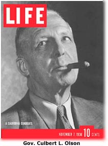 On Monday,
February 18, 1939, the “Magic Isle” as many called it, was opened to an
expectant public; special ceremonies were presided over by Governor Culbert
C. Olson who appeared before a decorative Golden Gate Bridge portal to
the exposition armed with a large key. With the opening of this portal,
the exposition commenced. Although not all the exhibition halls had yet
been completed, there were enough attractions, plus the novelty of the
site itself, to satisfy those who thronged the island on opening day. Notable
were the Tower of the Sun with its Elephant Towers, while many came to
regard the Federal Building as the most striking of all the buildings.
The landscaping and horticultural results attracted much favorable comment.
The extensive art work also merited approval; among the best murals were
those of Millard Sheets depicting California history. These were supplemented
by some borrowed European masterpieces. When one added to the above features
the scientific exhibits and recreational areas, it was apparent that there
was “something for everyone” in the Golden Gate International Exposition.
During its run, the exposition attracted 17 million visitors. However,
it was not a financial success; in October 1939, the Pageant of the Pacific
closed its gates, six weeks early and $4,166,000 in debt. It was decided
to reopen the exposition in 1940 in the hope of recouping these financial
losses. This was done in the spring of 1940 when Europe was in the convulsions
of war. However, the Fair went on as planned; when it finally closed its
doors in September 1940, an admirer wrote:
On Monday,
February 18, 1939, the “Magic Isle” as many called it, was opened to an
expectant public; special ceremonies were presided over by Governor Culbert
C. Olson who appeared before a decorative Golden Gate Bridge portal to
the exposition armed with a large key. With the opening of this portal,
the exposition commenced. Although not all the exhibition halls had yet
been completed, there were enough attractions, plus the novelty of the
site itself, to satisfy those who thronged the island on opening day. Notable
were the Tower of the Sun with its Elephant Towers, while many came to
regard the Federal Building as the most striking of all the buildings.
The landscaping and horticultural results attracted much favorable comment.
The extensive art work also merited approval; among the best murals were
those of Millard Sheets depicting California history. These were supplemented
by some borrowed European masterpieces. When one added to the above features
the scientific exhibits and recreational areas, it was apparent that there
was “something for everyone” in the Golden Gate International Exposition.
During its run, the exposition attracted 17 million visitors. However,
it was not a financial success; in October 1939, the Pageant of the Pacific
closed its gates, six weeks early and $4,166,000 in debt. It was decided
to reopen the exposition in 1940 in the hope of recouping these financial
losses. This was done in the spring of 1940 when Europe was in the convulsions
of war. However, the Fair went on as planned; when it finally closed its
doors in September 1940, an admirer wrote:
Before we
expected it, the day came to close the gates. It was a sad occasioned especially
for the rest of us who had found refreshment on Treasure Island. When the
final bills had been paid, it would be recorded that the Golden Gate International
Exposition, like so many others before and since, had lost money. The staff
compiled a final report, cleaned out the files and drifted away. [5]
Today Treasure
Island is owned by the Navy. After Pearl Harbor, the site was turned
over to the federal government by San Francisco and it is now one of
the West Coast’s main naval installations. Three of the expositions’ permanent
buildings are used by the Navy.
NOTES
AND SOURCES
Sources
While journalistic
sources are abundant for both bridges, neither has yet had as complete
accounts as they deserve. On the Bay Bridge, cf.
The San Francisco-Oakland
Bay Bridge (no author indicated, Chicago, 1936). On the Golden Gate
Bridge, best so far is Allen Brown, Golden Gate: Biography of a Bridge
(New York, 1965). On the Golden Gate International Exposition which celebrated
the completion of both bridges, cf. Richard Reinhardt, Treasure Island:
San Francisco’s Exposition Years (San Francisco, 1973).
Notes
I. These
appreciative words are in a mimeographed release published by the Golden
Gate Bridge District (no date, no author indicated) which contains much
information about the bridge.
2. Appropriately,
Strauss’s statue has been erected in an area close to the bridge. The inscription
reads as follows:
|
1870—
Joseph B. Strauss—1938
"The Man who Built the Bridge."
Here at the Golden Gate is the
Eternal Rainbow that he conceived
And set to form, a promise indeed
That the race of man shall
Endure unto the Ages.
Chief Engineer of the Golden Gate Bridge 1929-1937
|
3. A dramatic
test, which the Golden Gate Bridge passed successfully, came on Saturday,
December 1, 1951. Between 5:55 P.M. and 8:45 P.M. the bridge was closed
to traffic because of a violent storm which generated a gale with a velocity
of seventy miles an hour. The deck of the bridge swayed twenty-four
feet from side to side and five feet in the perpendicular dimension. Since
the bridge was designed to sustain a twenty-seven-foot sway,
no serious effects came from this dramatic moment. Close examination of
the structure later indicated only minor damage.
4. Poem:
“Mission Dolores” in A California Pilgrim (no author indicated,
San Francisco, 1884) p. 114.
5. The
Great Exposition; in the San Francisco Chronicle, October 14,
1973. The article is an adaptation of his book, Treasure Island
(San Francisco, 1973).
IN: San
Francisco, the Story of a City, by John Bernard McGloin. San Rafael,
Calif. : Presidio Press, 1978.
Return
to the top of the page.
|