The Daly City Earthquake of 1957:
What Does it Tell Us?
By Richard
Marsden
Richard Marsden graduated with honors from Churchill College,
University of Cambridge, with a degree in Natural Sciences (Geological).
He also holds a Masters Degree from the University of Durham. It was as
part of this that he worked with Drs. Mary Lou Zoback and Bruce Julian at
the U.S. Geological
Survey, Menlo Park, California, on the Daly City Earthquake of 1957. A
paper about the earthquake was presented to the Fall 1995 meeting of the
American Geophysical Union. The abstract can be
found on his homepage.
As a keen amateur astronomer, Richard served on the Committee of the
Cambridge University Astronomy Society in its 50th and 51st years.
Richard is also a major author of the CADIE
project - an
educational computer tool for diabetics. He currently works and lives in Houston, Texas.
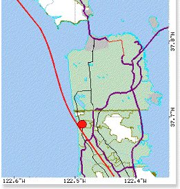
On 22 March 1957, the San Francisco Peninsula was rocked by an
earthquake
centered in the Daly City area that caused damage in Westlake District of
that
city,
and some damage in San Francisco.
Although only magnitude 5.3, this was the
largest earthquake on the Peninsula since 1906.
Recent work which has attempted to find the epicenter of the 1906 San
Francisco
earthquake has suggested an epicenter on or near the Peninsula.
Originally, this epicenter was thought to be at Point Reyes, but work using
distant seismograms suggests a more southerly epicenter.
Because it now appears that the Daly City earthquake occurred in the
region
where the 1906 earthquake was centered, the 1957 event suddenly becomes
more important for scientists, as well as the people who live and work in
the
Bay Area.
Unfortunately, the seismometers then in place in and around the San
Francisco
Bay
were not as numerous as they are now, so the earthquake mechanism data
derived from 1957 seismic recordings were not conclusive.
What is an earthquake mechanism?
The vast majority of earthquakes are due to blocks of rock which slide
along
fault
planes. An earthquake mechanism merely describes the orientation of the
plane in
which the earthquake moved.
By analysis of seismograms after an earthquake, it is possible to discover
the
orientation of the plane. Usually, it is assumed the earthquake occurred
at a point - the focus. The epicenter is the point lying on the Earth’s
surface, directly above the focus. Because the earthquake mechanism is just
for
this point, the mechanism is often called a “focal mechanism.”
This is extremely useful, because scientists can then characterize particular
earthquakes. This, in turn, allows us to work out why earthquakes happen.
There are three main kinds of earthquake mechanism:
1.) Strike-slip (Transform or “Sliding”) Faults
In these, the fault plane is vertical or near vertical, and the motion of one
block is in a horizontal direction parallel to the plane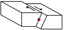 .
The most famous example is that of the main San Andreas Fault. In the
1906
Earthquake,
the west (Pacific) side moved north relative to east (California) side. There
is little or no vertical movement on the fault, although the surface may
show
local slumping and slippage. .
The most famous example is that of the main San Andreas Fault. In the
1906
Earthquake,
the west (Pacific) side moved north relative to east (California) side. There
is little or no vertical movement on the fault, although the surface may
show
local slumping and slippage.
These faults typically occur when a plate is moving sideways relative to an
adjoining one (eg. Pacific and North American Plates). They also occur
near
mid-ocean ridges (eg. central Atlantic), and combined with other fault
zones
(Kobe 1995 occurred on a transform fault).
2.) Compressional (“Thrust”) Faults
These occur where forces are pushing two blocks of rock together. 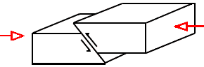 The fault
plane will be dipping, with the upper (“Hanging Wall”) block overriding
the
lower (“Foot Wall”) block. The fault
plane will be dipping, with the upper (“Hanging Wall”) block overriding
the
lower (“Foot Wall”) block.
These faults typically occur in mountain ranges where the thrusting of
blocks
causes mountain uplift (eg. Himalayas and Alps), or in subduction zones
(eg.
Japan).
Due to the compression, the crust tends to thicken, hence it is no
coincidence
that most areas of compressional faulting are of relatively high terrain.
3.) Extensional, or “Normal” Faults
These occur where rocks are being stretched. Again, there is a dipping
fault,
but the upper (“Hanging Wall”) block moves down. 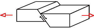 These are often likened to dominos leaning against one another.
This effect can be seen in Nevada, where the faults form the steep sides of
the
mountain ridges.
These are often likened to dominos leaning against one another.
This effect can be seen in Nevada, where the faults form the steep sides of
the
mountain ridges.
Due to the stretching, the crust tends to thin, so areas experiencing
extensional faulting tend to be low-lying. About 100 to 200 million
years
ago,
this occurred in the North Sea. This provided an ideal environment for oil
formation, and the area is still below sea level.
Extensional faults are also very common along mid-ocean ridges.
“So what was the Daly City Earthquake?” you ask. Because the San
Andreas
fault is predominately a transform fault, we would expect a
strike-slip
mechanism like that of the 1906 event and most other San Andrean
earthquakes -
even though it was only a moderately-sized earthquake.
Initial work immediately after the 1957 earthquake showed that this was
unlikely.
Unfortunately, the earthquake was limited in size, so records were limited.
During the summer on 1995, I worked with Dr. Mary Lou Zoback
and Dr. Bruce
Julian from the U.S. Geological Survey at Menlo Park, with help and using
methods developed by
Dr. Doug Dreger at U.C. Berkeley. We attempted to get all the records
still
extant. These data were combined with modern seismic-wave
modelling
methods, applied
to the better seismograms, to so reduce the number of possible earthquake
mechanisms.
We decided that the most likely mechanism was that of an extensional
event.
Isn’t this a bit strange?
At first sight it might be, but there are a number of pieces of evidence that
tell us that we should expect some extensional faulting near Daly City:
 1.) In recent years, a dense
network of seismometers has operated in the San Francisco Bay region.
This network picks up hundreds of small earthquakes — the vast majority
too small to feel. Along the San Andreas fault, two clusters are of note. In
the Santa Cruz mountains, there is a cluster of compressional
events related to the 1989 Loma Prieta earthquake. Another, smaller
cluster, lies in the Daly City. These are predominately extensional faults. 1.) In recent years, a dense
network of seismometers has operated in the San Francisco Bay region.
This network picks up hundreds of small earthquakes — the vast majority
too small to feel. Along the San Andreas fault, two clusters are of note. In
the Santa Cruz mountains, there is a cluster of compressional
events related to the 1989 Loma Prieta earthquake. Another, smaller
cluster, lies in the Daly City. These are predominately extensional faults.
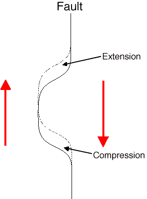
2.) The San Andreas fault is not dead straight, but has a number of small
kinks. Curving of strike-slip faults would be expected to lead to
compression or
extension faulting. In the Santa Cruz
mountains, the fault curves slightly to the left, whilst along the Golden Gate
section, it curves slightly to the
right. The Pacific plate is moving northwards, so it “hits” the American
plate
in the Santa Cruz mountains, but moves away from it in the Golden Gate
region.
This is why compression faults are seen in the Santa Cruz mountains, whilst
extensional faults are seen in the Daly City region. In fact, the Loma Prieta
earthquake was caused by a combination of compressional and strike-
slip
motions.
3.) This also explains the topography. Compressional faulting occurs in the
Santa Cruz mountains, hence the crust thickens, and mountains form. In the
Daly
City region, faulting is extensional, so the crust thins, hence the fault drops
below sea level.
This is a 44K WAV file
audio recording of the 1957 Daly City Earthquake.
The original is from a Benioff seismometer (T0=1sec, Tg=90sec)
recording made at the PAS (Pasadena) station 540 km [336 miles] from the
epicenter. This may sound like a long-period instrument, but it is
actually one of the shorter recordings that could be found. The original is a
paper (analog) record, later scanned at the University of California
Berkeley, and digitized at U.S.G.S., Menlo Park.
This recording is unfiltered, but speeded up 134 times—relative to
real-time—to make it audible. The recording, therefore, does not
sound very realistic with small PC speakers. It does sound surprisingly
authentic when played through a medium-to-low-end
high-fidelity amplifier. For best effect, set the bass control to “full.” The
results should allow you to hear the recorded 1957 earthquake vibrations
from the eaves of a four-story building, to the basement.
You may also experience the 1957 earthquake at the shake-table
located at the California Academy of Sciences’ Museum of Science and
Natural History in Golden Gate Park.
Return to the top of the page.
|